
Trace a Revere Street Address
A street-by-street search in Revere works best as a chain, not as a list of people. The assessor and GIS connect a street address to a parcel and an owner record. The Registry can then connect that parcel to recorded transfers. A local voter-file request may confirm that a registered voter was associated with an address, and historical directories may add an earlier household clue. Each source has a different purpose. An owner or a tax mailing address is not automatically a current resident, and a blank result does not establish that no one has a connection to the location.
- Search the address in Revere GIS, select the parcel, and record the legal address and parcel ID.
- Open the assessment and sales panels to distinguish the property details from any mailing address.
- Use the parcel, owner name, legal description, or street search in the Suffolk Registry of Deeds to locate recorded instruments.
- For a Revere-specific registered-voter question, contact the Election Department for the local public-record route rather than seeking the statewide file.
- For an older address, compare the available directory years and newspaper references with the deed trail before drawing a conclusion.
That sequence keeps the Revere street directory focused on verifiable address records. It also makes a name mismatch useful: a different legal description, book and page, or place name may explain why a street-only search failed.
Revere GIS Street Directory Tools
Revere GIS is the starting point when the address, owner name, or parcel ID is known. The official instructions show all three search paths, including an example parcel format of 15-255A-1. Select a result, then use the ASSESSMENT control to inspect the available parcel information. The map also exposes Owner, Assessment, Sales, and Links panels, so the street directory researcher can keep the parcel identifier beside any owner or sales clue. The city describes the GIS as an informational map tool, so verify a consequential detail with the appropriate custodian.
The Revere GIS parcel viewer shows the search and parcel tools used for an address-led lookup.
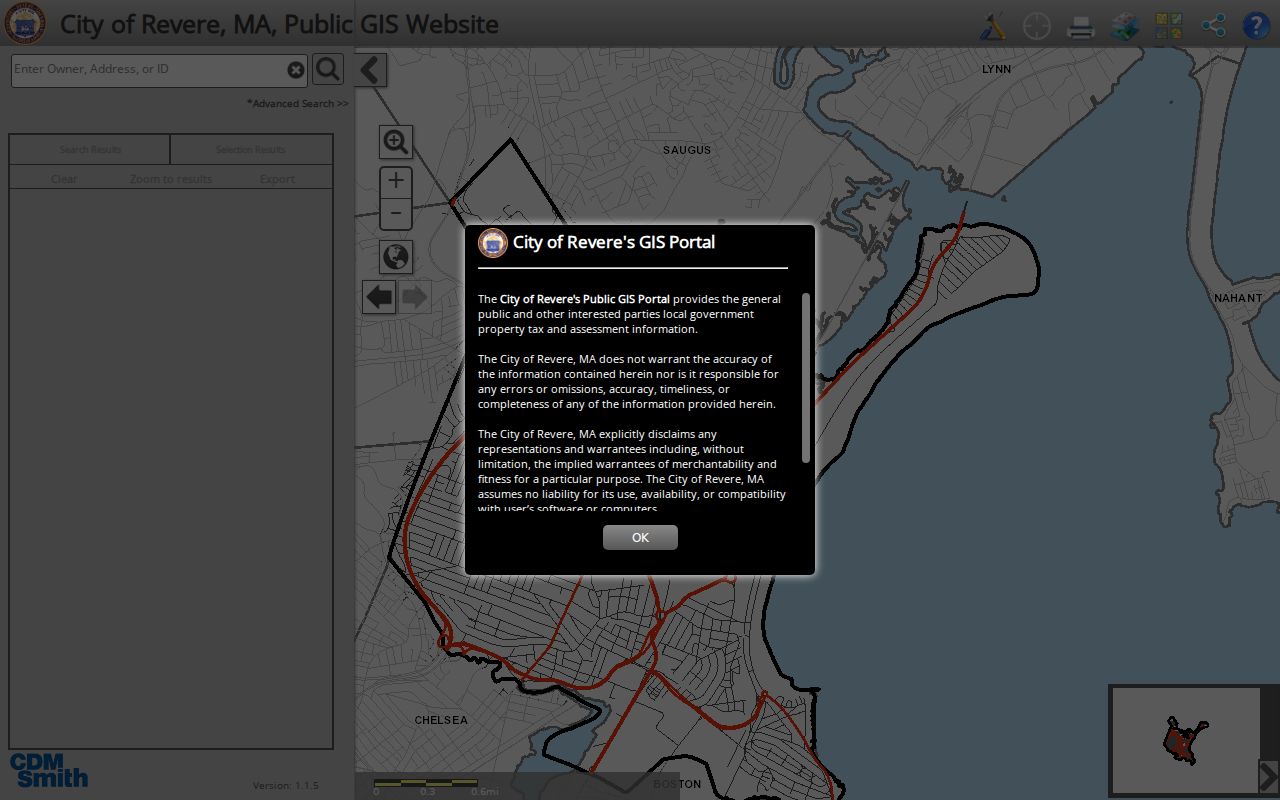
Use the selected parcel as the bridge to assessment, sales, abutters, and deed research, rather than assuming the map is a household roster.
| GIS control | How it works | Street-search use |
|---|---|---|
| Search bar | Accepts address, owner name, or parcel ID | Find the starting parcel |
| Advanced Search | Opens additional criteria | Refine a broad result |
| Search Results | Select a result row | Open parcel information |
| ASSESSMENT | Displays assessment data after selection | Check the parcel record |
| Owner, Sales, Links | Parcel panels and actions | Compare available owner and sales clues |
| Quick Maps | Voting, trash, recycling, and other layers | Add local map context |
| Get Abutters | Buffers a selected parcel by distance | Inspect nearby parcels |
| Export | Exports selection or search results | Keep a working parcel set |
Revere Address Records Compared
Several Revere and Suffolk sources are keyed to an address, but they do not answer the same question. Start with the source whose key matches the fact being checked. The table separates a parcel-owner connection, a record of physical work, a transfer history, and a registered-voter record. Combining them carefully is more reliable than reading any one row as a full street directory.
| Address source | Custodian | Useful evidence | Access route |
|---|---|---|---|
| Assessing database | Revere Assessors | Owner, legal address, parcel and assessment details as exposed on the live card | City assessor page |
| GIS parcel viewer | City of Revere | Parcel geometry, abutters, layers, assessment links | Online map viewer |
| Recorded deeds and plans | Suffolk Registry of Deeds | Parties, dates, book/page, legal description, plan references | Online index and Registry counter |
| Permit files | Revere Building Department | Application, review, inspection, licensing, or development file activity | CitizenServe or City Clerk request |
| Local voter records | Revere Election Department | Public registered-voter fields, subject to confidentiality rules | Municipal request |
| Historical directories | State Library and local reference sources | Past address and household clues in selected years | Library and scanned volumes |
Parcel IDs and legal descriptions are especially helpful when names repeat. They tie the modern map record to Registry material and can survive a change in the way a street is written.
A property mailing address deserves a separate note in a Revere street search. It is where tax or official correspondence is sent and can be outside the city, while the situs address identifies the parcel itself. The two fields can explain why an owner name appears with a different city, but neither field alone proves present residence. Compare them with the record date and, where appropriate, a local voter or historical-directory source.
Search Revere Permits by Address
Revere’s Building Department uses CitizenServe for public-view applications, reviews, inspections, and documents dating from March 2018. An account or login may be needed. The published instructions say to choose Search, select a File Type, and enter only the street number and street name without a suffix such as Street, Road, or Avenue. The File Type menu covers Permits, Licensing, and Development Projects, with permit categories that include building, electrical, plumbing, gas, sheet metal, and mechanical work.
The Building Department’s CitizenServe instructions identify the legal-address search path and file categories.
A missed permit search often calls for the legal assessing address or parcel ID, not a second guess at the postal form of the address.
Older permit material does not appear through that online cutoff. The Revere City Clerk is the access contact for older building records and public-record requests for City Hall departments. A permit identifies activity connected to a property, not a census of everyone who may have been there.
Note: Permit entries from the online system begin in March 2018, so older Revere records require the City Clerk public-records route.
Revere Street Address Terms
Address formats are a frequent source of false negatives in a Revere street directory search. The assessor and permit systems use the municipal legal or assessing address. Tax correspondence may go somewhere else, and a postal presentation can use a different format. When a modern address does not appear in an old instrument, the parcel number, Registry book and page, plan, or legal description is the stronger connecting detail.
- Parcel
- A mapped unit of property identified in the Revere GIS and linked to municipal assessment information.
- Situs address
- The legal or assessing address for the property itself. It can differ from the owner’s mailing address and does not prove present residence.
- Plat
- A map or plan showing lots and boundaries. Suffolk Registry plan records can help when an older deed lacks a usable street address.
- Criss-cross directory
- A directory arranged by address rather than surname. No complete Revere criss-cross run was confirmed, so ask reference staff which available volumes include street sections.
The distinction matters most at the point where CitizenServe, GIS, and a deed appear to disagree. Test the legal address and parcel ID first, then compare the deed’s plan references before assuming the records describe different places.
Follow Revere Deeds by Street
The Suffolk Registry recorded-land portal indexes and images names from 1973, beginning with Book 8595. The 1970 through 1972 period is being verified and re-indexed, so an apparent blank needs caution. Older image material reaches back to Book 194 in 1800 through Unindexed Property Search. The Registry warns that its website is not the complete historical record and says genealogy and other historical work is best done in person at 24 New Chardon Street in Boston.
For a Revere street search, begin with Property Search or the owner name found in the parcel record. If an older deed omits or misstates the address, switch to the legal description, plan, book and page, then use grantor and grantee names. Plans from 2004 forward have an additional name/address route. The Registry also provides recorded-land, registered-land, and plan search modes, so select the correct office before comparing a result.
| Registry result detail | Why it matters |
|---|---|
| Party name and role | Separates a grantor from a grantee in the transfer trail |
| Document type | Identifies the indexed instrument category |
| Recording date | Places the instrument in time |
| Book, page, or document number | Provides a stable route back to the record |
| Property or legal-description information | Helps distinguish similar street addresses |
| Image access | Allows review of an indexed and imaged instrument |
Revere Voter Records by Address
A Revere Election Department request is the appropriate public-record path for municipal voter information. Massachusetts guidance identifies public local-list fields such as name, residence address, party, date of birth, active or inactive status, and voter ID, while phone, email, veteran status, permanent absentee status, and confidential records are withheld. The statewide voter list is not a public record, so it is not a substitute for the local route.
Use the GIS Quick Maps menu to add voting and neighborhood context around a parcel. That layer can explain civic geography, but it does not identify a person. For a local record request, the Election Department is at 281 Broadway and can be reached at 781-286-8200. Written requests can seek paper or electronic local records, with production costs allowed under the Massachusetts Public Records Law.
Note: A local voter record supports registered-voter research only, and confidential registrations are protected from public address disclosure.
Revere Street Buffers and Layers
Revere’s GIS is particularly useful on a dense street because the Get Abutters tool works from a selected parcel. Enter a distance, choose feet or meters, select Buffer, and inspect the returned parcels in Search Results. The selection can be exported, and the documented workflow can produce mailing labels. That is a parcel-neighborhood tool, not a person lookup, but it can reveal which parcels should be checked through their own assessment and deed records.
Quick Maps adds voting, trash, recycling, flood, MBTA, and service context, while the neighborhood layer can place a parcel in areas such as Beachmont or Library. Those map labels help differentiate locations with similar street clues. They should not be used to infer who resides at an address.
Revere Street Directory History
For historical address work, the Massachusetts State Library identifies selected Revere city-directory volumes from 1876 through 1940. Search the street or address portion when it exists, then use the surname index and nearby available years to test a move or a changed household reference. The Revere Directory Book has the fuller collection trail; here, the key point is that a directory entry is a dated clue, not proof of current occupancy.
Older records may use North Chelsea, the name Revere carried before 1871. Search both place names in nineteenth-century directories, maps, and newspapers. No official Revere street-renumbering or street-renaming date was located, so bridge an apparent address change with Registry plans, legal descriptions, city maps, and original newspaper images rather than assuming one numbering system stayed fixed.
Limits of a Revere Street Directory
Address records leave important gaps. The assessor and GIS identify parcels and owner-related details, not every current occupant. Voter records cover registered voters but exclude confidential registrations. Utility customers, motor-vehicle addresses, protected court parties, and many nonpublic contact fields are not part of a public street roll. A historical directory can name a person at an address for one published year, but the available Revere run is irregular and does not establish a continuous household history.
Lawful personal use. Use Revere address records for family history, property research, civic questions, or other lawful personal purposes. Do not use them to stalk, harass, intimidate, or harm another person.
When evidence conflicts, keep the record type and date beside each result. That simple practice prevents a mailing address, dated directory entry, or recorded transfer from being mistaken for a present-residence finding.